[WOW] WORKSHOP ON WATER: RE-MEDIATING VACANT LANDSCAPES
MArch Advanced Architecture Thesis (Semester1) . Authors: Paulina Naruseviciute/Laura Petruskeviciute
Glasgow has twice as much D&V land as the whole Scotland together. 42% of derelict land is in deprived zones. Deprivation is the highest in Glasgow among all Scottish cities. It came together with sudden deindustrialization and closure of the factories which were the main source of jobs.
Municipal has set the goal to treat and release the development potential of at least 100 ha of vacant land every year employing innovative approaches, such as setting up programmes and funding to support community and individual initiatives towards vacant and derelict land use.
We see temporary use as an integrative part of urban planning. D&V land laying underused for many years could become the test bed or play space for young people, communities or address environmental issues: such as reduce air or land pollution, deal with flood risk management or become a place for solar energy.
Also many creative minds, living in a world of commercialism and profit, are trying nevertheless , to create spaces that reflects and nurture their vision of the future.
Derelict and vacant land is also a concern for property owners. The undiscovered district, the dead end on the urban landscape, the blind spot in public perception might all in fact be set in motion, brought to the light of day by (temporary) use.
Open spaces create barriers between neighborhoods. Reintegrating such spaces in the city, creating paths between them, reconnecting disparate urban spaces is something that projects by creative urban mileus can actively promote.
We believe in experimentation and searching for new forms of reanimating and appropriating spaces.
The first journal 'Glasgow Atlas of Vacancy' is an outcome of the first semester research that looks at the problem, scale and scope in relation to D&V land location. In the next journal the systematic design approach will be introduced which seeks to create social corridors through temporary use.
Second part of Atlas concentrates on 5 priority zones for reuse of D&V land. Sites marked as a D&V are taken and analyzed separately in order to measure their potential.
Who owns the land? Whose responsibility is to improve our environment which some of us live nearby, walk by, play? Neglected and abandoned spaces expose the problems of poverty, health, poor children play areas, security and crime. We came up with the tools of enabling people to edit their environment:
“How to spot my 20 sqm”- the number of 20 sqm is based on the ratio of derelict & vacant land and population in Glasgow. The guide offersdirections what to do when you see the ‘forgotten’ land and want to use it for a while. It was prepared with the help of Glasgow city Council derelict and vacant land department.
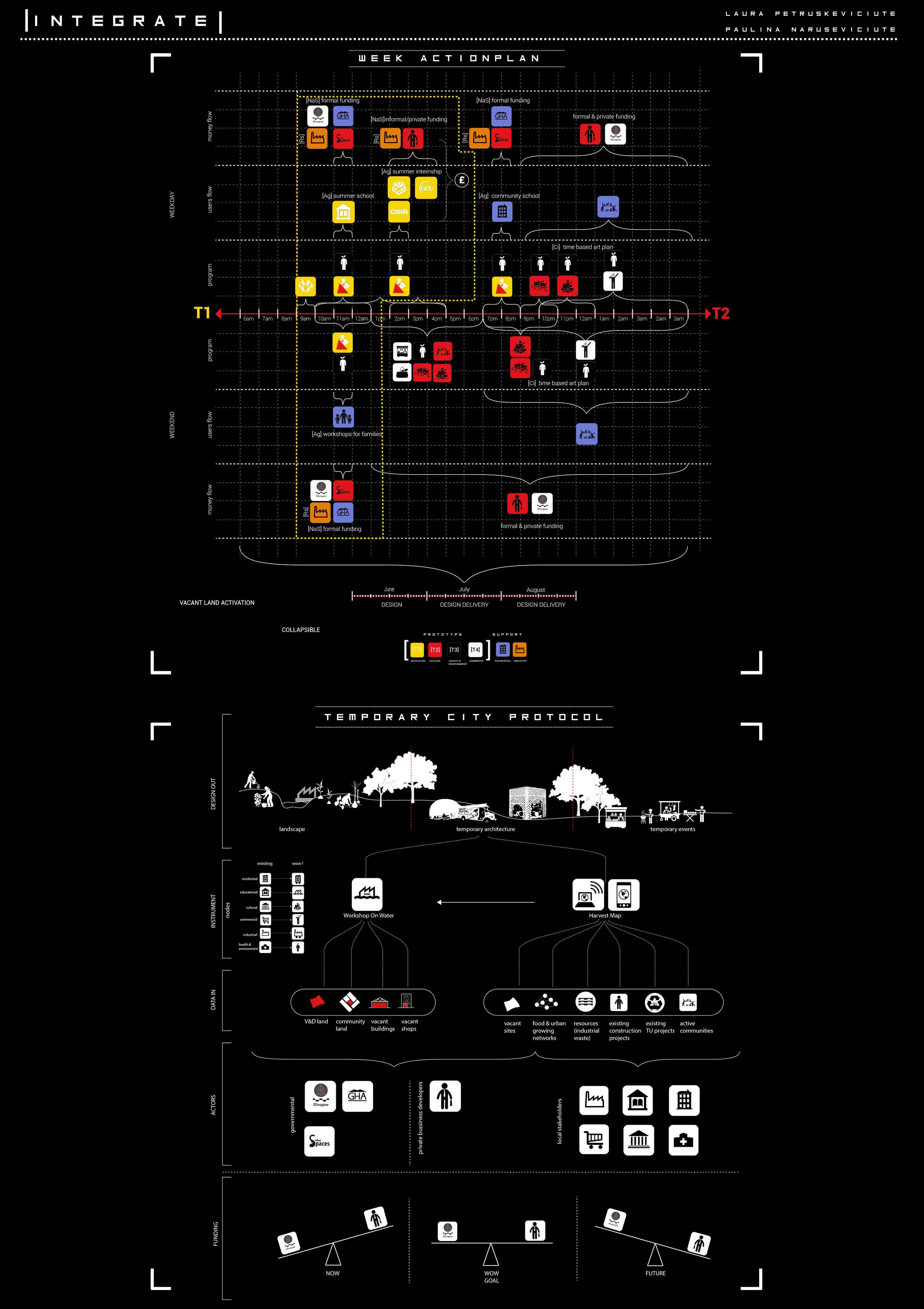
‘Harvest Map’ - a digital tool to allow people to see the available cheap or free materials in the area which could be reused, up-cycled in order to encourage people use them for temporary space activation projects.
Harvest map is an urban tool which shows available sources in a proximity of a planned construction site. However, we consider that harvest map could become a tool for every citizen enabling them to manipulate their environment in vacant and derelict sites around Glasgow. To achieve that, it is important to track not only materials or energy flows, but also existing networks and collaborations as well as previous use of site. Multi-layering of different information would enable its users to create not only the most efficient decisions while sourcing their project, but also to create socially sustainable and attractive projects while connecting back to existing networks.
It aims to indicate :
- vacant & derelict sites( in 5 priority zones only)
- previous use of site
- land ownership
- available materials network
- existing networks/possible collaborators
It aims to indicate :
- vacant & derelict sites( in 5 priority zones only)
- previous use of site
- land ownership
- available materials network
- existing networks/possible collaborators
It is a dynamic data base which is changing with urban environment and conditions. Ideally the web platform should be accessible for various groups of people to add information while expanding the overall network.
Land typologies:
Vacant Land - In general terms vacant land is previously developed land, without physical constraint, which the Planning Authority has indicated is currently available for redevelopment.
Derelict Land - In general a site can be classed as derelict if it is on previously developed land, which has a physical constraint caused by its previous use, which hampers its redevelopment or naturalisation.

“Trap the Gap” was an urban game which summarized our research into the game based on real facts in temporary urbanism.
The object of the game is to bridge the gaps between different border condition actors through collaborative and strategic linking trying to collect the highest amount of scores.
The game emphasizes the importance of collaboration gaining personal benefit. It also forces to think of different actors involved in urban fabric as well as makes aware of derelict and vacant land potential which could be released through open space/play space & reduce pollution strategies. It gives a glimpse to successful space reactivation/temporary projects around the globe through Title Deed cards.

Urban Game 'Trap the Gap'


BRIDGING THE GAPS: [WOW] WORKSHOP ON WATER

MArch Advanced Architecture Thesis (Semester 2)
SPACE IS A NECESSITY NOT A LUXURY.
The previous “Atlas of Vacancy” introduces the problem ofincredible amount of derelict and vacant land scattered around Glasgow. This problem results in many issues: such as health decile, safety, poverty and crime.
At the moment Glasgow City Council has introduced the plan which allows communities to get a small amount of money to develop the eyesore land bits around their neighbourhoods into gardens, playgrounds or art spaces. However, talking from our experience, for the person who is not experienced in such ‘business’ and paperwork, the process of getting the land, funding and tools will seem too complicated.
Our role is to act as a mediating agent and ease the process of temporary occupation. During the first semester we aimed to create toolkits and adatabase which would allow people to see the derelict spaces, existing similar projects and cheap or free of charge materials at one glance. During the next half a yearwe are using this database for our design purposes. This semester we were in search of affordable production and workspaces which would allow people to remain in the city and start or continue their activities here. We created the school which offers experimental design techniques in order to inhabit vacant landscapes. However, temporary architecture we offer is a temporary solution and testing ground for permanent projects.
The magazine has 5 topics.
1.The firstone gives a glance for the reader to our proposal.
2.The second one explains why we are introducing temporariness as a solution.
3.The third chapter introduces the reader to the research and analysis of the specific site we are indicating as a starting point of the project.
4. The 4th chapterfocuses on the design techniques and methodologies .
5. The last paragraph presents our view how we see the project working within the wider city infrastructure and cultural/business framework . As well as it presents our expectations in terms of project development.
WOW (Workshop On Water) is an instrument to reactivate vacant and derelict land, the school which plants a seed for temporary architecture culture in Glasgow.
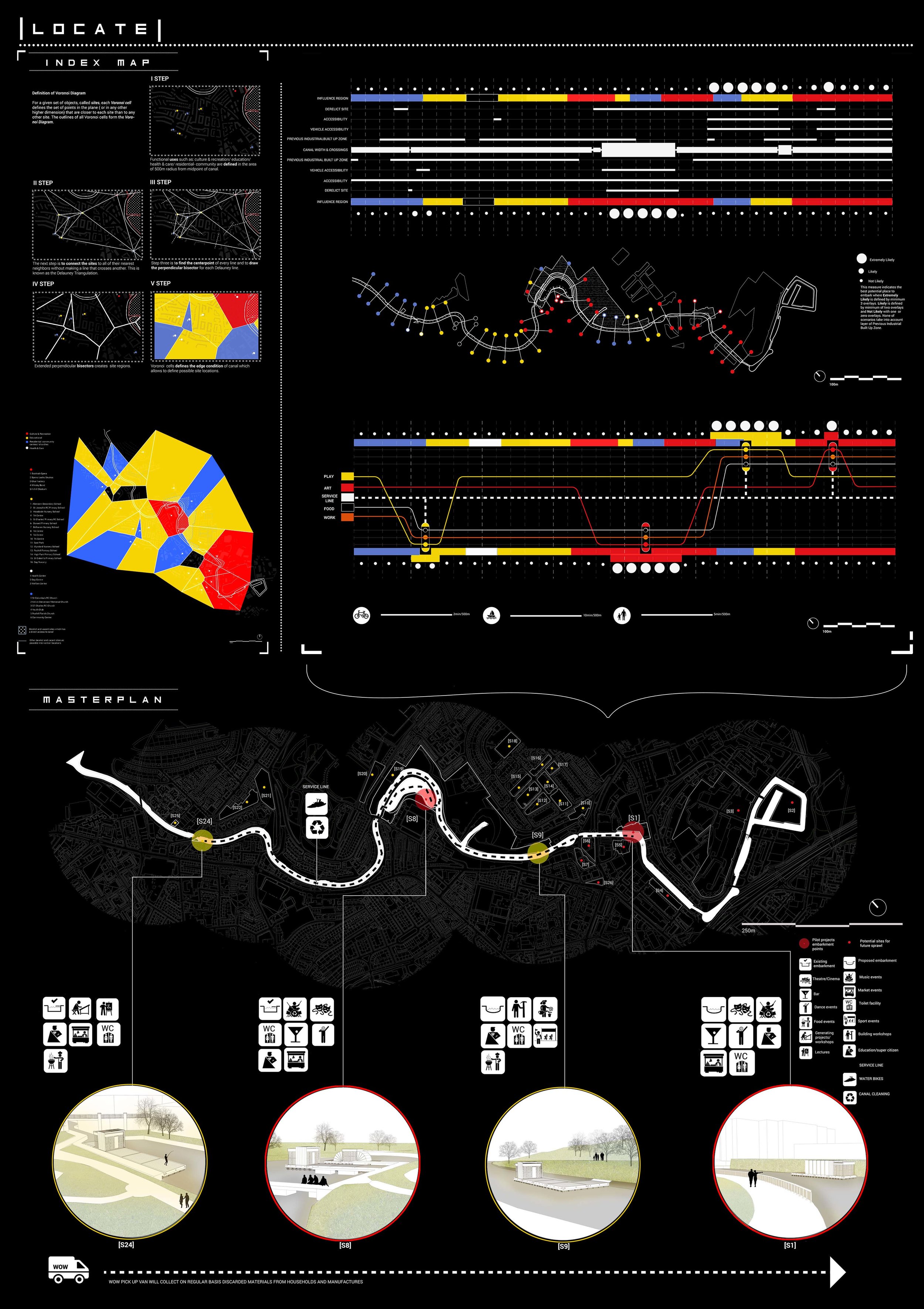
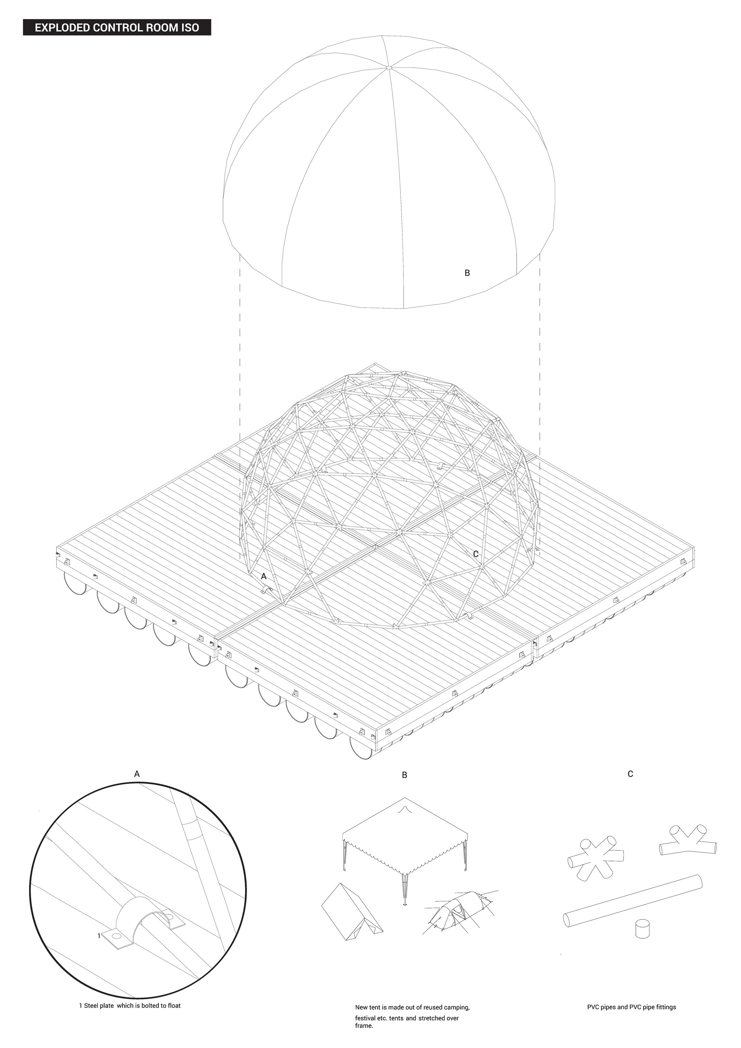
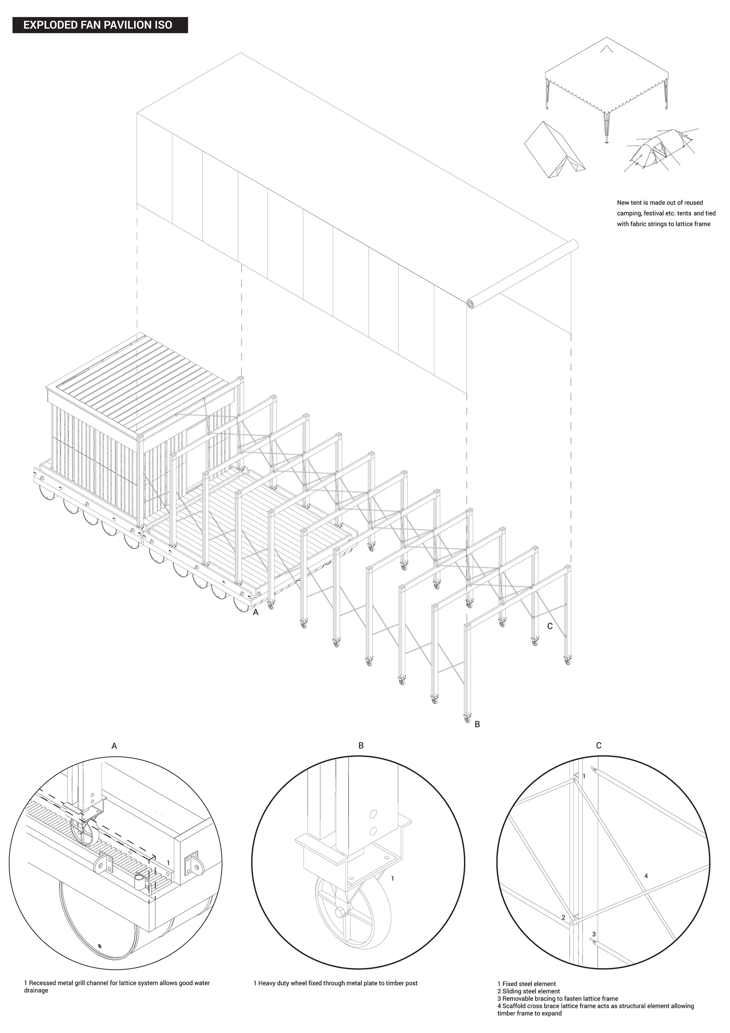
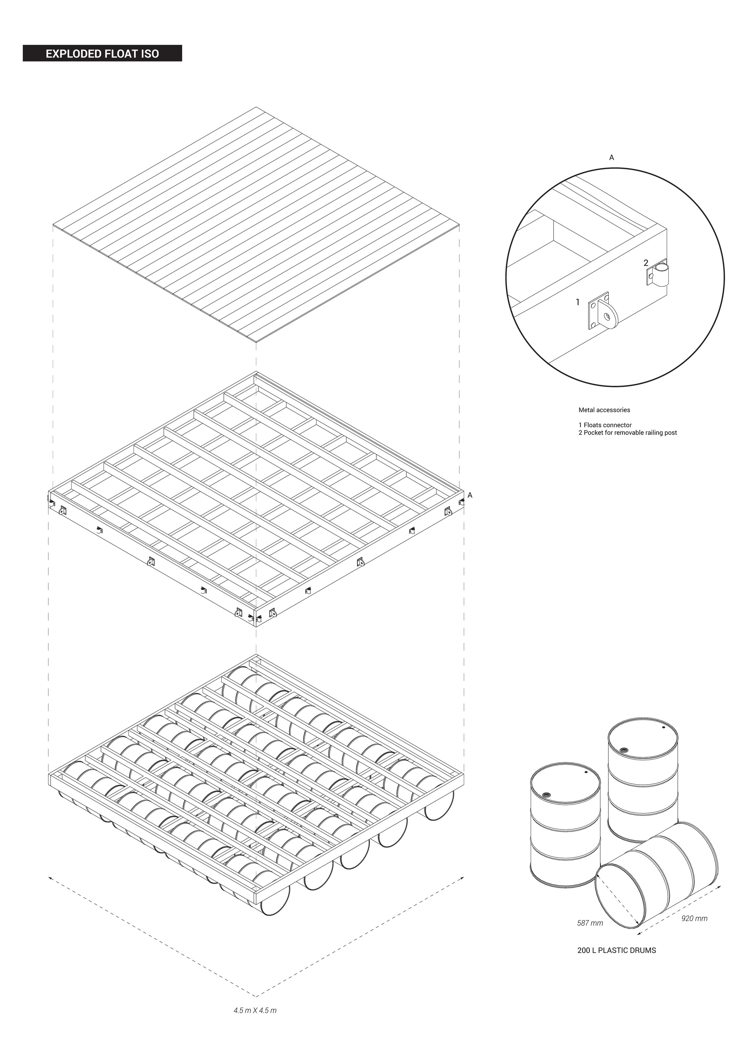
The starting point of the WOW is Forth & Clyde canal (Glasgow Branch) which previously was highly industrial and now there are vast areas of the land left vacant. Water allows the school move freely from one place to another in order to activate bigger area faster. WOW units sit on
the canal based on intensive functional uses in the area and their influence zones defined according to Voronoi diagram. The usage influence zone, topographical conditions and accessibility defines units’ locations (stop points) on the canal. The active and pre-organised units ( Art Incubator, PlayPod unit, Control Station and Culture Kitchen) are on the water, however they are prototypes of rentable units that can go on any site . It can be rented or easily constructed by community or any individual.
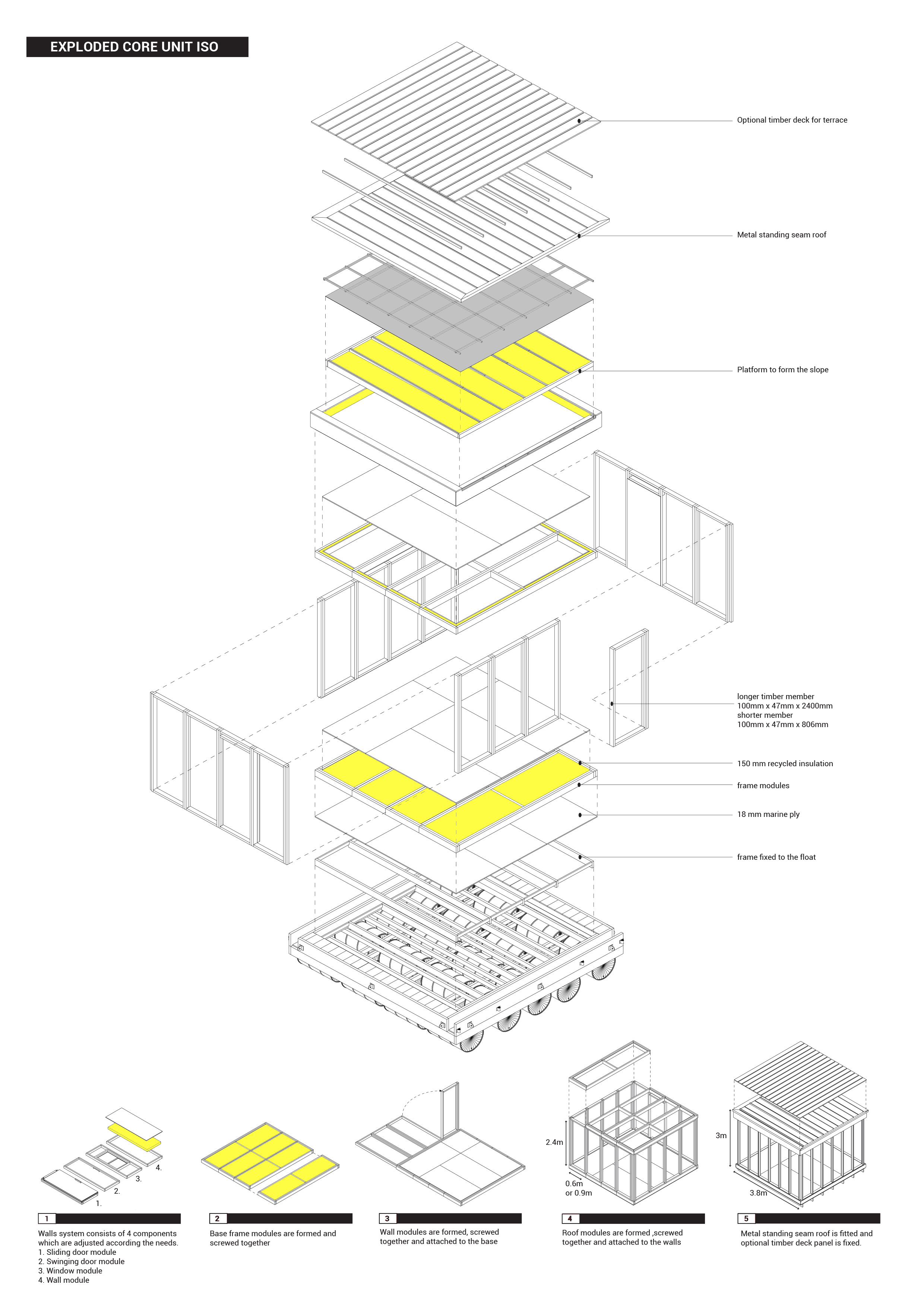
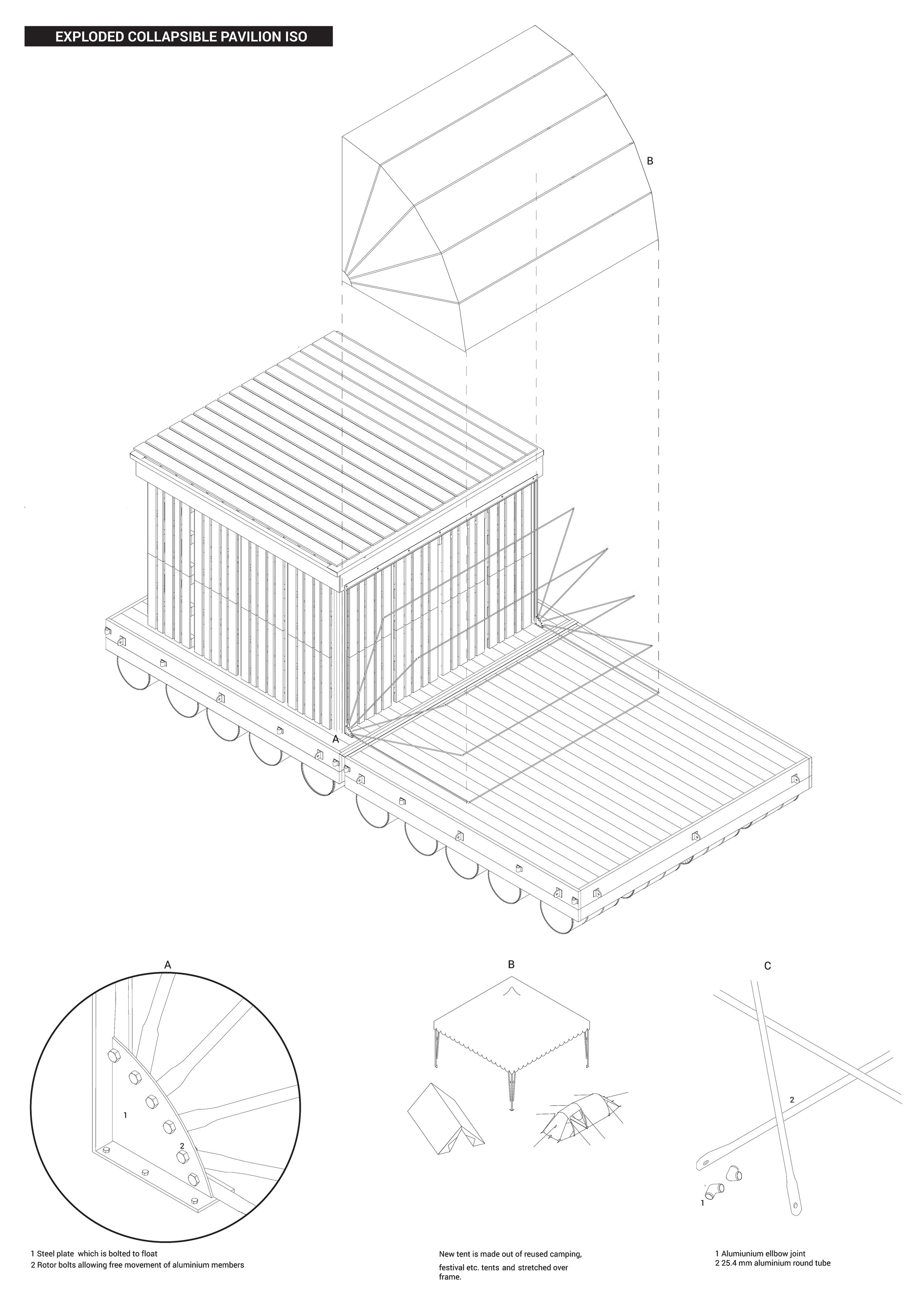
The units structure is based on modular pieces which are easy to construct and can be prefabricated off site. This allows WoW to work in other cities and countries too. The facade can be picked from the facade library- Harvest Map. Facade materials are recyclables and up-cycled waste or industrial products.
For WoW to work in full power and programme the digital management and control system is created which allows people to book units for certain events as well as feed in information about available physical and digital resources and existing collaborative networks.
WoW prescribed plan is 5 years after which temporary use should be integrated and be a part of permanent planning. Furthermore, the mobile units stays and promotes self-organised DIY spaces culture. The Floating school moves to other canal/ river in other city or country.
FROM DISORDER TO SELF-ORGANIZATION| FROM VACANT TO OCCUPIED
The duration of prototype is proposed to be 5 years. During this period project will have 4 PHASES.
I PHASE‘RAISING AWARENESS’
Pilot projects are placed on the most suitable sites along the canal as indicated in previous research. These projects aims to cultivate interest and raise awareness through proposed events and activities gathering around as much as possible users.
II PHASE ‘ACTIVE PARTICIPATION’
Pilot projects starts to be used on daily basis by community members and other people around on daily basis. Empowered users starts to see the potential on D&V site in their neighborhoods .
III PHASE‘ SPILLOVER TO OTHER SITES’
Pilot projects ‘replicants’ are built on other sites to sustain the activities.
IV PHASE ‘ SELF- ORGANIZATION’
After period of 5 years there a two possibilities forpilot project to operate:
a. it can move to heal other sites
b. it can be recycled creating a minimal impact to environment
Pilot project aims to leave behind self-managed system of D&V sites use benefiting environment and people not only living around but also attracting a wider audience as well.